


Lasers can shed light on where even small species live on the landscape and help wildlife managers plan for their conservation, a new study shows.
Researchers used LiDAR to model red tree vole (Arborimus longicaudus) habitat in southwest Oregon. Threatened by logging, the species, which inhabits western Oregon and northern California’s old-growth forests, is a candidate for listing under the Endangered Species Act.
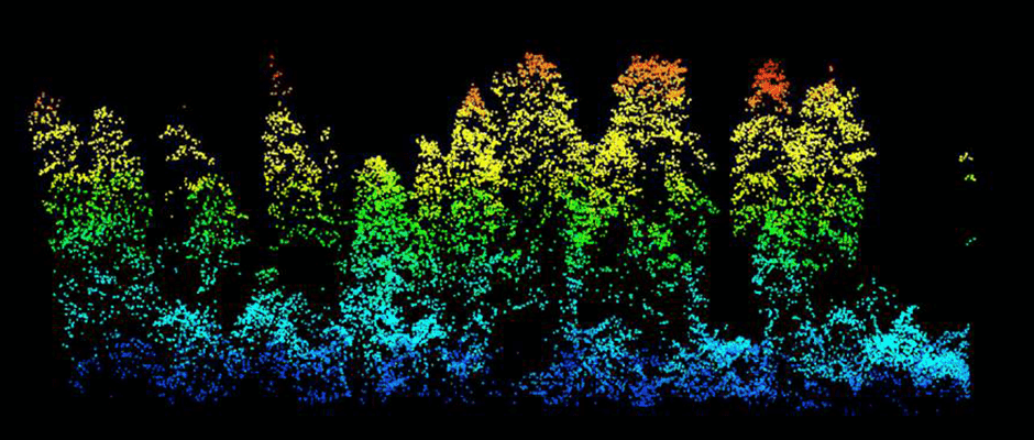
LiDAR, which stands for “light detection and ranging,” fires laser pulses to measure topography and create a three-dimensional picture of the landscape.
“With this technology, we can develop habitat models that use information relevant to very tiny animals like red tree voles in the tops of trees and create models at a high resolution useful to managers that need to make decisions at the local level,” said Aaron Johnston, Affiliate Assistant Professor with the School of Environmental and Forest Sciences at the University of Washington and lead author of the paper in The Journal of Wildlife Management. “But we can predict habitat for broad-scale management decisions as well.”
Shooting out 100,000 laser pulses per second, LiDAR records the time it takes for the light to travel from the aircraft to the ground and back, said Johnston, a TWS member. “They may intercept trees, rocks, shrubs or bare ground,” he said. “With that information, you can model the landscape and its features at very high resolution.”
The researchers compared finely-detailed LiDAR data on canopy structure from the Bureau of Land Management with documented locations of vole nests to gauge the probability of nest occurrences throughout the research site. They found that voles often nested in large trees in the interior of the forest, which aligned with previous research revealing a relationship between the species and the complex canopy and intricate structure of old-growth forests. To ensure the animal persists, they recommended that managers maintain forest cover, especially older trees, within 220 yards of vole nests.
The researchers found that LiDAR data can help guide resource managers in a variety of ways, including prioritizing areas for the red tree vole’s conservation and identifying potential vole habitat for environmental compliance surveys.
Johnston believes LiDAR could also be helpful mapping habitat for other species with small home ranges.
Since about 2000, LiDAR has been increasingly applied to ecology and forestry, Johnston said. It’s expensive and existing data only covers half the country, mostly in low quality, but the U.S. Geological Survey is currently leading an effort to expand it to the entire nation and regularly update it, he said.
Article by Julia John