


Interior Secretary Ryan Zinke has released an update to his proposed reorganization of the department, after the Western Governors’ Association raised concerns about his initial plans.
Zinke has been discussing the reorganization plans for several months, and additional details continue to be developed. Many expected the 2019 budget proposal to include more information, but aside from designating $17.5 to fund the reorganization efforts, it didn’t provide any additional details.
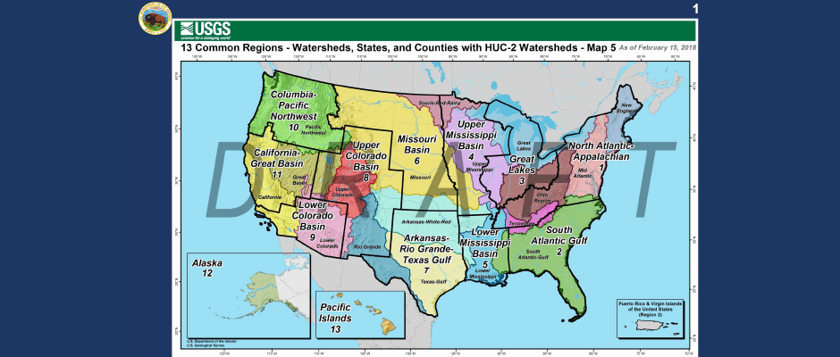
The original map outlined 13 common regions based on watersheds and ecological features. It was designed to replace the current model, where each agency has a unique region map, with 40 distinct regions across the department. Uniting nine bureaus with common regions with individual regional leaders is intended to improve communication between bureaus, streamline management decisions and approval processes and improve relationships with state and tribal governments.
The Western Governors, however, criticized the original map and DOI’s failure to solicit their feedback before the plan was released.
The revised map, release in mid-February, continues to be based on 13 common regions and watersheds, but it makes adjustments to account for state political boundaries. On Feb. 23, state and county leaders wrote a letter expressing their appreciation for the revised map following state boundaries more closely. In the updated map, only a few states are divided into more than one region.
Although watersheds can serve as excellent geographic and environmental boundaries, the reorganization was jarring to officials more accustomed to operating under political boundaries such as state or county lines. Since most federally managed lands are in the West, Western states would be most heavily impacted by the changes. Zinke also hopes to move some agency headquarters, such as the Bureau of Land Management, to western cities to keep managers more informed about frontline operations and more accessible to local stakeholders.
Some of the changes are projected to be enacted during the second half of fiscal year 2018, which ends in September. Fully implementing the new plan across the country is expected to take several years. Interior plans to use Alaska as a test area for the reorganization since it is a large area that already has several agencies operating from the same city.
DOI currently employs about 70,000 people. The reorganization is expected to eliminate about 4,000 full-time-equivalent positions. Forty percent of current DOI employees will be eligible for retirement within the next five years, so some positions could be eliminated or reduced when employees retire.
Article by Madilyn Jarman