
Share this article
WSB: Infrared cameras can help count feral horses
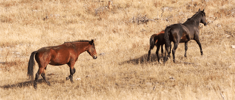
Current methods of monitoring feral horses and burros can be dangerous for the people conducting aerial surveys and disturbing to animals. Helicopters have to fly at low elevations — 50 to 200 feet above ground level — to allow biologists to observe and count animals.
Researchers recently looked at an alternative method for surveying feral horses, using high-resolution infrared technology in combination with distance sampling analyses. These methods put surveyors 2,000 to 5,000 feet in the air, where they detected hotspots on a monitor screen that they could zoom in on to confirm species.
“When it comes to feral horses, we always want to come up with new ways to count them that are appropriate and give us reliable results to help management,” said TWS member Kate Schoenecker, an ecologist for the U.S. Geological Survey and affiliate faculty at Colorado State University. She led the study published in The Wildlife Society Bulletin. “It’s also about putting more tools in the toolbox for wild horse and burro managers.”
Schoenecker and her colleagues tested the use of infrared camera technology and distance sampling analyses on already known feral horse (Equus caballus) numbers in the open sagebrush habitat of McCullough Peaks Herd Management Area in Wyoming. The group Friends of a Legacy were observing the horses in the area and knew the true population size. Schoenecker was sent a sealed envelope with the true number of horses after analysis was complete.
“It was like a secret envelope,” Schoenecker said. “We didn’t open it until we knew the analysis was complete. It was kind of fun.”
The team found that infrared technology in combination with distance sampling resulted in population numbers that were within 10 percent of the actual numbers collected by the Bureau of Land Management and FOAL, which did on-the-ground monitoring.
While the infrared technology allowed for precise spotting of horses, Schoenecker said, it didn’t allow for detection of horses where they were covered by vegetation. That’s where the distance sampling analyses came in.
“What we wanted to do is apply a correction factor such as distance sampling to get a true population estimate as opposed to just a minimum count,” she said. “So what you’re doing with distance sampling is building a detection function or detection curve and being able to see if it met the assumptions that animals farther away from the aircraft are harder to detect.”
In this case, the distance sampling didn’t have to do much correcting, Schoenecker said, but that might be because the study area was pretty open, without much vegetation blocking the animals and the infrared camera had high detection of animals.
“The real test for how this works with distance sampling will be revealed when it’s tested in other habitat types and the study is repeated,” she said.
For now, Schoenecker hopes the price for infrared camera technology comes down so more vendors are able to do infrared flights. Right now, it’s more expensive than helicopter surveys.
“We hope to improve the safety of getting the data,” she said. “The more noninvasive or lower-invasive tools we can develop, the better for everyone — including the animals, including the wildlife.”
TWS members can log in to Your Membership to read this paper in the Wildlife Society Bulletin. Go to Publications and then Wildlife Society Bulletin.

Header Image: Infrared technology and distance sampling used together can provide an accurate feral horse count, according to new research. ©James Abbott
Related Posts

Q&A: TEK and the wildlife profession
Tracing a trajectory from “elitism” to “equity”
New maps expand picture of big-game migrations in the West
The maps document 33 mule deer, pronghorn and elk routes
Deep snows deter red foxes
Frequent, larger snow events brought on by climate change could reduce fox populations